Field of view visualization using 3D GIS software (FOV3D)
IntroductionTo get a better understanding of the atmospheric volume that is monitored by a (meteor) camera, one may use 3D GIS-software such as Google Earth to interactively explore the field of view of a camera. To do this, we created a PHP-script called "FOV3D". The script generates a 3D semi-transparant polygon representing the field of view of a given camera.
The script produces output in the KML-format, which is an XML-based language for describing geospatial data. KML-files can be imported into GIS-software such as Google Earth, NASA World Wind and ArcGIS. However, the files generated by this script have only been verified to work with Google Earth.

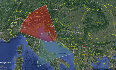
Example of a FOV3D-generated file in Google Earth, showing the MRG double-station setup in the Netherlands.
Example generated by CSV File
Simple user interface
Use the form below to create a Google Earth-file for your camera setup.
Upload Platepar
Use the form below to upload your platepar file and generate a Google Earth-file for your camera setup.
Upload CSV
Use the form below to upload your csv file and generate a Google Earth-file for your camera setup.
Every row of the CSV file contains an entry for one station, the columns are the following:
Station name, Hex color (-1 for random), Latitude (+N, deg), Longitude (+E, deg), Elevation (m), Azimuth 1, Altitude 1, Azimuth 2, Altitude 2, ...
The field of view of every station is bound by rays of azimuth and altitude emanating from the position of the station. The rays are given by Azimuth 1, Altitude 1, Azimuth 2, Altitude 2, etc. entries. There is no limit on the number of rays. The CSV file should be without a header.
Here is an example of entries for two stations in Croatia:
				CMN_CIO,0000ff,43.51,16.3,20,266.65,46.64,272.67,37.41,277.36,27.33,280.97,17.06,283.77,10,298.04,10,313.73,10,329.43,10,343.66,10,346.58,17.01,350.18,27.35,354.81,37.48,0.77,46.73,340.78,53.79,313.39,56.67,286.26,53.62

				CMN_VID,ff0000,45.28,13.72,218,110.39,50.46,117.32,41.02,122.52,30.72,126.52,20.2,129.82,10.08,143.48,11.42,158.75,11.97,173.97,11.31,187.46,10,190.46,19.77,194.27,30.08,199.17,40.16,205.47,49.44,186.84,56.42,159.25,59.78,130.72,57.16
Notes:
- The script will generate a KML-file that should be opened locally on your computer using Google Earth.
- All angles should be entered in decimal degrees.
- Western longitudes and southern latitudes should be given as negative values.
- For azimuth, north is 0 degrees and south is 180 degrees.
- The simple user interface will generate a rectangular field of view. The 4 corners of this rectangle will have the following relative coordinates (azimuth, elevation):
- 1: (azimuth - width/2, elevation + height/2);
- 2: (azimuth + width/2, elevation + height/2);
- 3: (azimuth + width/2, elevation - height/2);
- 4: (azimuth - width/2, elevation - height/2).
- The "Range" value is the distance in kilometer from the camera to the end of the field of view. If "Fixed upper altitude" is checked, then the field of view will be drawn up to the given altitude.